JEO 11 - News Roundup - 20 Feb 2026
A periodic news roundup on the space, Earth observation, and geospatial industries in Japan.

Welcome to Japan Earth Observer (JEO), a free monthly newsletter with a news roundup and one in-depth article about the space, Earth observation and geospatial industries in Japan.
In this news roundup from January and early February, there are a pile of funding, contract, and partnership announcements as well as a flurry of Year 2 Space Strategy Fund awards.
On to the news…
News & Announcements
💱 Contracts and Funding
- Japan’s Ministry of Defense (JMoD) has awarded a major contract to a consortium led by Mitsubishi Electric [SatNews] to build a new satellite constellation for defense and intelligence imagery. This is a key JMoD project that will be operating for the next several years. The RFP and bidding process for the new system [JEO 5] began last spring, and the initial contract will run through March 2031. JMoD will not control or operate the constellation directly. Rather, Mitsubishi Electric and two other consortium members, Mitsui & Co. (a trading company) and SKY Perfect JSAT, will create a Special Purpose Company (SPC) that will own and operate the constellation. JMoD will have first access to all imagery, but the consortium will also be able to sell excess capacity in the commercial marketplace. The consortium combines long-established, incumbent firms like Mitsubishi Electric and Mitsui with agile startups iQPS, Synspective, and Axelspace in the hopes of cultivating rapid technical development. Presumably, iQPS and Synspective will provide the SAR capacity and Axelspace will provide the multi-spectral optical.
- ispace has been awarded a JAXA contract to study lunar debris concerns. Old satellites, collision effects, expended rocket bodies, and other detritus already clutters low Earth orbit (LEO). However, the Earth's gravity and atmosphere will eventually pull much of this debris to burn up in the atmosphere. The moon, however, is much smaller and has no atmosphere, and it won't take much debris to make lunar orbit a dangerous proposition. The United Nations’ Committee on the Peaceful Uses of Outer Space (COPUOS) and other organizations have been developing guidelines for reduction of LEO orbital debris, but there are no such guidelines for either the lunar surface or orbits. JAXA's contract anticipates this future challenge as an increasing number of landers and orbiters head to the moon.
- Astroscale France and French company Exotrail announced a partnership to develop deorbiting capabilities for low Earth orbit satellites [Astroscale]. This partnership combines Astroscale's spacecraft design and mission operations expertise with Exotrail's advanced electric propulsion systems. The partnership will aim to provide cost-effective deorbiting services for constellation operators who must comply with evolving debris mitigation regulations. They are aiming to fly their first mission together before 2030.
- Synspective and Airbus Defence and Space have signed a data framework agreement that will add Synspective's SAR data capture capabilities into Airbus's EO portfolio [Synspective], building on the existing Airbus SAR satellites (TerraSAR-X, TanDEM-X, and PAZ). Synspective provides relatively high resolution (25 cm), inclined orbits that improve coverage of equatorial regions, and increasing revisit cadence as they build toward a 30-satellite constellation by 2028.
- iQPS closed a syndicated 5-year loan agreement for ¥6.2 billion (~US $40 million) [iQPS] to continue scaling of its SAR satellite constellation, including manufacturing, launch services, and ground infrastructure development. Mizuho Bank was the lead arranger with almost a dozen additional banks providing funds.
- Why does this matter? iQPS is a publicly traded company, so it can raise capital by selling shares if it really needs to. However, that would dilute the value of each outstanding share. By borrowing a relatively short-term (5 years) private loan at a low interest rate, it will be able to build out its constellation more rapidly, and thereby begin generating the operating cash it needs to repay the loan.
- Axelspace (アクセルスペース) got its contract renewed with the Geospatial Information Authority of Japan (GSI) (国土地理院) to provide its AxelGlobe satellite imagery to national basemap projects managed by the Ministry of Land, Infrastructure, Transport and Tourism (). The contract is a vote of confidence that Axelspace's imagery quality meets government standards for precision and reliability.
- Space BD (株式会社スペースBD) closed a ¥2.4 billion (~US $15.5 million) Series C fundraising round [Space BD] to support growth of its launch services brokerage business. The round was led by Mitsubishi HC Capital.
- Space BD also signed an MOU with Kick Space Technologies to market and sell its satellite components and systems.
- Japan LEO Shachu (日本低軌道社中) closed a round of investment from Mitsubishi Heavy Industries and Mitsubishi Electric. The firm was established in July 2024 as a wholly owned subsidiary of Mitsui & Co. to pursue next generation LEO space station components such as a future research module and cargo vessel. The amount of investment or how it will be applied is not clear.
Space Strategy Fund Announcements since January 2026
| Theme | |
|---|---|
| 衛星等 Satellites | Awards |
| Frequency sharing technologies for satellite to ground communication |
|
| Rakuten Mobile | Development and demonstration of dynamic spectrum sharing [SatNews] |
| Technology for orbital transfer, in-orbit refueling, and space logistics |
|
| NEC Corporation | Develop of an inter-orbital transport vehicle |
| Pale Blue | Develop ultra-small inter-orbital transport vehicles for cislunar transportation [Pale Blue] |
| Mitsubishi Electric | Develop a general-purpose inter-orbital transport vehicle utilizing autonomous RPOD technology |
| Astroscale | Develop electric propellant refueling technology for geostationary orbital services [Astroscale] |
| Yokohama National Univ. | Develop interdisciplinary analytical methods for space logistics decision support |
| 探査等 Exploration | Awards |
| High-precision landing technology in the lunar polar regions |
|
| ispace | High-precision landing technology for lunar south pole and support for payload activities in the polar regions using a communications relay satellite [ispace] |
| Orbital data center construction technology |
|
| SpaceBlast | Build on-orbit data centers using high reliability edge computing |
| 分野共通 Common Areas | Awards |
| Solving environmental testing challenges for spacecraft |
|
| IMV Corp | Establish an environmental test facility for spacecraft |
| High Energy Accelerator Research Organization (KEK) |
Develop a proton beamline for single-event evaluation |
| Japan Atomic Energy Agency (JAEA) | Develop a spacecraft radiation test facility using the proton beam at J-PARC (a high intensity proton accelerator facility) |
| Japan Atomic Energy Agency (JAEA) | Develop radiation test facilities at the JAEA Tokai Tandem Accelerator |
| National Research and Development Agency (RIKEN) |
Develop advanced semiconductor testing environment with heavy ion beam delivery system |
| National Institutes for Quantum and Radiological Science and Technology (QST) |
Establish infrastructure for space radiation testing using particle beam therapy equipment |
| SEESE Corp. | Build a radiation testing facility |
| SX-CRANE, a space-transfer and new industry seeds creation center |
|
| Tokyo Univ. of Marine Science and Technology |
Develop next-generation positioning and navigation technology |
| Tokyo Univ. of Science | Develop environmental sensors and small payloads for future manned missions to Mars |
| Tokyo Univ. of Science | Space medical and habitat development center |
| Yamagata Univ. | Innovative Space Gastronomy Technology Development Center (STAR-MEALS) |
| Waseda Univ. | Space quality-of-life (QOL) R&D center for civilians living in space |
🛰️ Technology and Infrastructure
-
JAXA has released an interim report on the investigation into the H3 flight 8 failure [Ars Technica] and the loss of the Michibiki 5 navigation satellite, and it's a master class in expressing both the mechanics and the interim outcome of a launch investigation. In case you haven't been following this incident, Stage 1 completed without a hitch. The problems began when the payload fairing separated. Shortly after, the payload adapter broke off, sending the navigation satellite tumbling off the second stage. As the satellite broke away, fuel pipes supplying the second stage were damaged, causing a pressure loss on the initial burn and then failure of the second burn. Without the full burn of the second stage, nothing reached orbit, everything falling back into the ocean.
The presentation of the interim report [JAXA - Japanese] to the Ministry of Education, Culture, Sports, Science and Technology (MEXT) is remarkable for a combination of transparency and appropriate visualization and detail. I don't think I've ever seen this level of detail in a launch failure investigation debrief, outside perhaps the Challenger space shuttle disaster. Every slide is marked as unchanged, revision, or a new slide. Photos and sensor telemetry graphs are lined up with the results of relevant previous launches.
Finally, there is a summary Fault Tree Analysis (FTA) (故障の木解析) organized into primary, secondary, and tertiary failure sources and the status of each branch of the tree. The analysis is careful not to draw conclusions or lay blame on any component for which there is no evidence. In the software engineering world this would be a "blameless postmortem", a structured, post-incident review focusing on systemic, process-driven causes, rather than individual human error. This approach fosters psychological safety, enabling teams to openly discuss failures in a manner that raises the odds of preventing recurrence.
- My take: When I read these slides, it increases my confidence that JAXA, MHI, Mitsubishi Electric and the other partners will determine a root cause and take steps to mitigate it. This is a high stakes investigation, though. Not only has the Michibiki 7 launch been delayed, the MMX probe launch to Mars is scheduled in late 2026 after a previous 2 year delay due to H3 development problems. And there are cargo supply missions to the ISS planned as well.
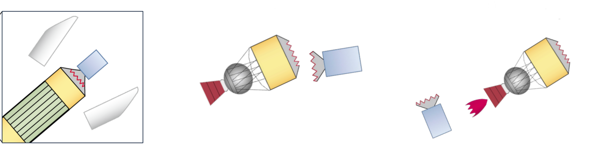
Diagram of H3 second stage failure on flight 8. Source: JAXA
- My take: When I read these slides, it increases my confidence that JAXA, MHI, Mitsubishi Electric and the other partners will determine a root cause and take steps to mitigate it. This is a high stakes investigation, though. Not only has the Michibiki 7 launch been delayed, the MMX probe launch to Mars is scheduled in late 2026 after a previous 2 year delay due to H3 development problems. And there are cargo supply missions to the ISS planned as well.
-
Infostellar and Antaris have announced a partnership aimed at integrating their cloud-native ground station and satellite mission planning software tooling [SatNews]. Antaris provides software to create a digital twin of a satellite and to simulate and manage satellite missions from design through end-of-life. Infostellar's StellarStation software supports scheduling and execution of data downlink and command uplink across diverse ground station networks. This new partnership builds on a partnership agreement Infostellar made with Japanese technology services firm Fusic in November 2025.
- Why does this matter? While we are all marveling at the magic of orbiting eyes in the sky, a lot of the action is happening on the ground. LEO and MEO satellites are spinning so fast that the data they capture has to be sent down in radio bursts that skip across a network of ground station antennas. The ground segment is often quite complex: it's fragmented across multiple vendors, there is diverse hardware, and antennas operate on a variety of frequency bands (usually X, S, or Ka-band). By integrating StellarStation with Antaris, satellite owners can automate scheduling and execution of data transfers to and from satellites from within the Antaris software interface, streamlining ground station planning.
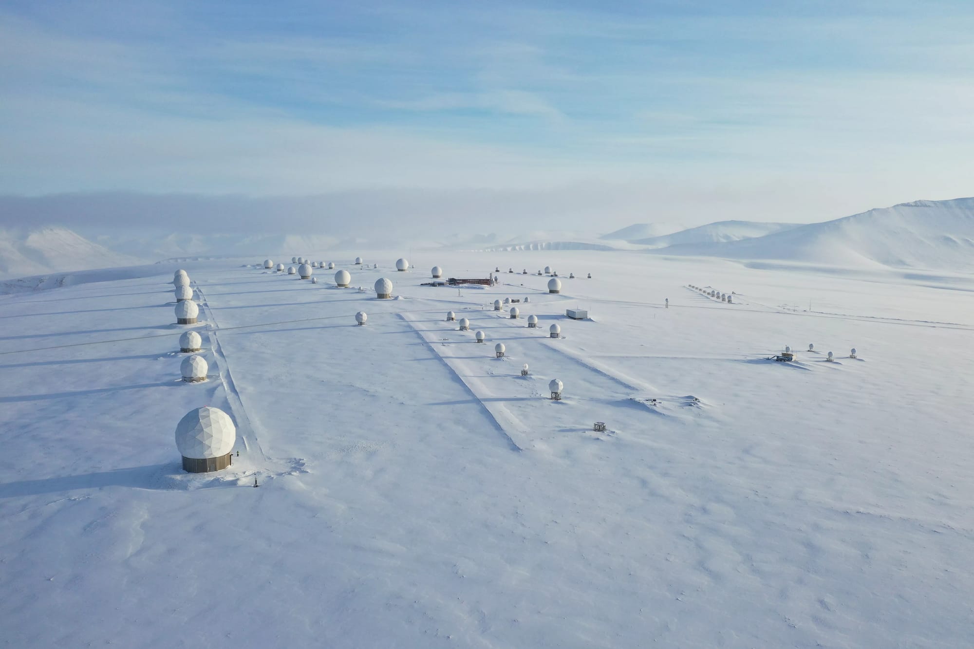
Photo of KSAT Svalbard Norway ground station. Source: NOAA NESDIS
- Why does this matter? While we are all marveling at the magic of orbiting eyes in the sky, a lot of the action is happening on the ground. LEO and MEO satellites are spinning so fast that the data they capture has to be sent down in radio bursts that skip across a network of ground station antennas. The ground segment is often quite complex: it's fragmented across multiple vendors, there is diverse hardware, and antennas operate on a variety of frequency bands (usually X, S, or Ka-band). By integrating StellarStation with Antaris, satellite owners can automate scheduling and execution of data transfers to and from satellites from within the Antaris software interface, streamlining ground station planning.
-
L3Harris has completed a critical design review for sensors that will be launched on the Himwari-10 weather satellite [SatNews] that is expected to be launched in 2030. The new advanced imager will build on the success of Himawari-9 by adding two new spectral bands to improve water vapor measurement and seven others for enhanced resolution. In addition to Himawari 8/9, the L3Harris Advanced Baseline Imager (ABI) is the same primary payload as the U.S. NOAA GOES-R series (GOES-16, -17, -18, and -19) and Korea's GEO-KOMPSAT-2A. The newest generation of the ABI has 12 spectral bands, rather than 4, 4x the spatial resolution, and 5x the temporal coverage.
- Why does this matter? The fact that a single supplier, L3Harris, supplies the imager for an entire generation of advanced weather satellites could potentially be a vulnerability, but it means that the weather data collected from East Asia to the Atlantic Ocean can be integrated seamlessly. L3Harris is also clearly not resting on its laurels as it continues to make significant advances in the capabilities of its products.
-
Panasonic has developed a portable 3D indoor mapping device that costs 80% less and can map an interior space in one-tenth the time [Nikkei Asia] of conventional methods. The 3D laser scanner, branded as @mapper, will be released in February and cost about ¥2 million (~US$12,600) per unit. The device consists of a handheld wand and a tablet display. While digital building information models (BIM) are common for brand new factories and infrastructure, older facilities often differ substantially from their original blueprints, if any blueprints even exist. If an operator or owner wants to upgrade or make improvements, a digital model of the existing facility makes the design and development process much easier. The ability to rapidly and cheaply create digital 3D models will also be useful for documenting historic sites.
- Why does this matter? This device is clearly aimed at generating digital documentation for physical facilities. However, laser scanning sensors are a key component of many autonomous vehicles and other robotic devices. Low cost methods for laser scanning will doubtless have applications for scenarios beyond facilities mapping.

3D model of suspension bridge generated with @mapper device. Source: Panasonic Holdings
- Why does this matter? This device is clearly aimed at generating digital documentation for physical facilities. However, laser scanning sensors are a key component of many autonomous vehicles and other robotic devices. Low cost methods for laser scanning will doubtless have applications for scenarios beyond facilities mapping.
-
Mitsubishi Electric (MELCO) (三菱電機株式会社) has selected Terran Orbital's Nebula satellite bus platform [SatNews] for a planned Quantum Key Distribution (QKD) and optical network demonstration satellite. MELCO is working with Japan's National Institute of Information and Communications Technology (NICT) (情報通信研究機構). The quantum keys are aimed at securing the data being transmitted via the optical communications. This is a real feather in Terran Orbital's cap because Mitsubishi Electric already manufactures the reliable, advanced DS-2000 satellite bus. But while Mitsubishi's bus is designed for multi-ton, long lifespan, geostationary satellites, this mission calls for a microsatellite of less than 130kg. The Nebula bus is equipped with large reaction wheels that enable high precision and high accuracy pointing needed for optical links and integrated Hall-effect thrusters for maintaining orbit and later disposal. Further, Terran can deliver on an 18 month timeline.
-
UACJ will invest in new forges in order to manufacture aluminum rocket fuselage rings in Japan. The objective is to increase the launch cadence of JAXA's medium-heavy lift H3 rocket, a major priority for JAXA. UACJ previously manufactured the aluminum ring structures in Japan for Mitsubishi Heavy Industries for the previous H-IIA rocket model, but the H3 fuselage has a bigger diameter and manufacturing was moved to U.S. suppliers for the H3. UACJ is the 4th largest aluminum roller in the world and is the largest in Japan with 50% market share. It is the result of a 2013 merger between Furukawa-Sky Aluminum and Sumitomo Light Metal Industries, but the roots of those companies date back to 1897. In addition to rocket fuselage parts, they also make other structural components for rockets and satellites that require aluminum alloys with high rigidity and low thermal expansion.
- Why does this matter? On the surface, this decision is unrelated to geopolitics. By manufacturing the parts in Japan, the shipping time and expenses are both reduced, enabling faster turnarounds at lower cost. However, shifting the work to Japan also reduces exchange rate and tariff uncertainty. And it won't be cheap. UACJ expects to invest ¥12 billion (~US $77 million) to build the new foundry in Oyama and have it running by 2029. JAXA has agreed to subsidize up to ¥6 billion of the cost.
-
Vast, one of several efforts to build a commercial space station before the end of the ISS, is opening a subsidiary, Vast Japan and an office in Tokyo [Vast] and has appointed Yamazaki Naoko to be the first General Manager. Yamazaki is a high octane selection for Vast. She is a former JAXA astronaut that flew as a mission specialist on the STS-131 Space Shuttle Discovery, an assembly and resupply mission to the ISS. She served as a member of the National Space Policy Committee of the Cabinet Office from 2012 to 2022 and currently chairs the Subcommittee on Space Development and Utilization at the Ministry of Education, Culture, Sports, Science and Technology (MEXT). She also co-founded the Space Port Japan Association in 2018 and serves as the Representative Director. While Vast does have Japan Manned Space Systems Corporation (JAMSS) as a key partner, it does not currently have any major Japanese investors. However, it clearly sees a market in Japan for hosting commercial payloads in LEO.
-
Kokusai Kogyo (KKC) (国際航業株式会社) has released Geozén, a cloud native geospatial data platform that integrates disparate business data – CRM, sales, images, video, infrastructure, asset management, BIM/CIM – by using geography as the common key. The new product enables customers to combine several isolated data silos into a single unified data lake that can be queried, support applications, and more easily enable LLM AI models to add value. Kokusai Kogyo has a venerable background in aerial surveying, GIS database development, application development, and data sales. A product like Geozén may enable KKC to sell into large, complex businesses that would not normally be conventional GIS customers by solving difficult data integration problems.
-
SPACE SHIFT (株式会社SPACE SHIFT) has extended its SateAIs product with two new AI models for detecting ships and oil slicks (Japanese). Ship detection enables maritime traffic monitoring, fishing fleet tracking, and potential maritime security (unauthorized vessel detection). Oil slick detection supports environmental compliance monitoring, spill response, and offshore infrastructure management. These specific AI models are leveraging SAR data, but in the broader SateAI product SPACE SHIFT uses optical, multi-spectral, and SAR data. It has productized its geospatial data analysis and AI expertise into six packages aimed at specific usage types:
- City - planning, real estate, local government, finance
- Ocean - marine transport, insurance, national government
- Earth - disaster response, construction, insurance, government
- Environment - forestry, environmental consulting, carbon accounting, ESG
- Agriculture - food, agriculture, local government
- Time - land use change, infrastructure, city planning
-
SKY Perfect JSAT (スカパーJSAT株式会社) has been selected by NASA as a ground station for tracking the crewed Artemis II mission [JSAT] (Japanese) expected to launch Mar - Apr 2026. SKY Perfect JSAT maintains a network of antennas and ground control stations that it uses to track and communicate with its own satellites as well as provide ground station services to other organizations. In this case, it will leverage its Doppler radar shift measurement capacity to help track the crewed Orion spacecraft on its 10-day trip to the Moon and back. NASA has its own extensive spacecraft tracking and communications network, but it supplements it with private capacity when needed. In this case, JSAT had begun providing a near-Earth object tracking service in Sept 2025 called “JSAT Space Line”, and it’s this new capacity it will leverage for the first for a cislunar tracking mission.
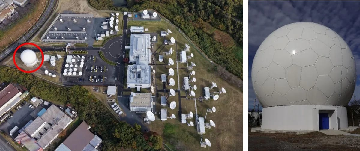
SKY Perfect JSAT antenna and ground station facility in Ibaraki with a closeup of the radome that covers the antenna. Source: SKY Perfect JSAT -
Weathernews (株式会社ウェザーニューズ) has recently rolled out several new and enhanced geospatial data products. Weathernews is Japan's largest private weather company, operating both domestic and global weather services. It does not own any of its own weather satellites, but it operates ground receiving stations for multiple weather satellite systems, and is probably one of the most innovative commercial weather services firms in the world.
In addition to the usual consumer-focused weather services to which we are all accustomed, Weathernews has developed a global set of specialized products for maritime shipping, airlines, railways, retail, construction, med-evac services, professional sports teams, and energy infrastructure. In fact, the company's origins were in providing specialized weather forecasting services for mariners. Inspired by the sinking of a cargo ship in Onahama Port and the death of 15 mariners caused by a bomb cyclone, Ishibashi Hiroyoshi set out to improve marine forecasts. As president of the Japanese subsidiary of Ocean Routes, a marine meteorological research company based in the United States, he grew the firm to 40 people. In 1986, he negotiated a management buyout of the Japan operations and established Weathernews. The company grew rapidly, creating subsidiaries in the United States, South Korea, China, and elsewhere. In 1993 Weathernews merged with its former parent company, Ocean Routes.
They seem to have continued innovating in the years since, creating customized forecasting services for power utilities, establishing a Global Ice Center for Arctic shipping routes, setting up a specialized Tropical Cyclone Center, launched their first WNISAT-1 satellite in 2013, acquired French weather company METNEX in 2017, launched the WNISAT-1R satellite the same year. In December 2025 they held the inaugural Weather and Climate Forecasting Conference in Tokyo, with a focus on applications of AI for forecasting.
In addition to the usual consumer-focused weather services to which we are all accustomed, Weathernews has developed global specialized products for maritime shipping, airlines, railways, retail, construction, and energy infrastructure. In December they held the inaugural Weather and Climate Forecasting Conference in Tokyo, with a focus on applications of AI for forecasting. New services rolled out since January include:
- An hourly pollen forecasts (Japanese) that combine a network of more than 1,000 pollen observation sensor stations with satellite weather models
- A new conversational AI “Weather Agent” that answers natural language questions (Japanese) about weather and climate based on Weathernews satellite imagery, forecast models, and their archive of historical data. Every government and commercial entity working with weather is using or testing AI to improve forecasts, but this is the first consumer-focused AI interface I’ve seen that provides access to a trove of weather and climate data to non-expert users. It supports fairly precise questions like “will my laundry dry by 4p?” or “what is the likely impact of wind on Saturday’s marathon course?” as well as specialized questions related to gardening, camping/outdoors, and golf. It only seems to be available in Japan for now.
- Enhanced lightning risk monitoring services (Japanese) that combine ground-based sensors with lightning sensors on the latest weather satellites. Lightning risk alerts are particularly useful for critical infrastructure, aviation, and outdoor services.
- 2026 cherry blossom bloom forecast (Japanese) beginning 21 March in Tokyo and Fukuoka, slightly ahead of recent seasons
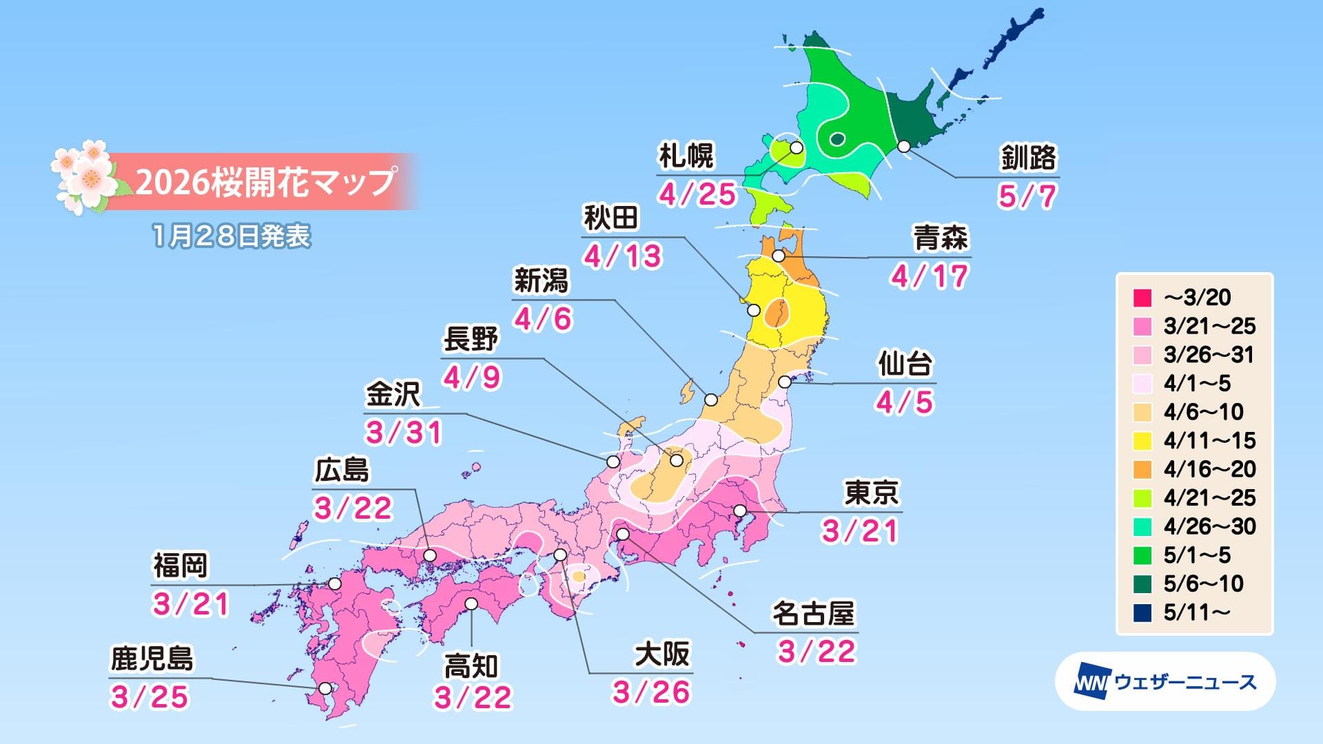
Cherry blossom bloom forecast start date by city. Source; Weathernews
🔭 Science
-
Researchers at the University of Tokyo's Institute of Industrial Science (IIS) have developed a machine learning model using satellite imagery to predict risks of bear-human encounters. 2025 was a record year for bear attacks in Japan, particularly in the northern Tohoku region. Asiatic black bears are native to Japan and are generally solitary creatures that live in dense forests. A key reason for the 2025 spike was poor autumn harvest of acorns and beechnuts in forests, causing bears to range more widely for alternative food sources. But, perhaps counterintuitively, declining human populations are also increasing the risk of human-bear encounters. The number of bear hunters is declining and aging with the overall population. In addition, rapid declines in rural population is reducing the areas of land that are actively managed by humans, leading the bears to expand their habitats into areas they would not have previously entered. The new model aims to forecast areas in which these risks could rise in the future using satellite data on topography, human settlement patterns, and land cover.
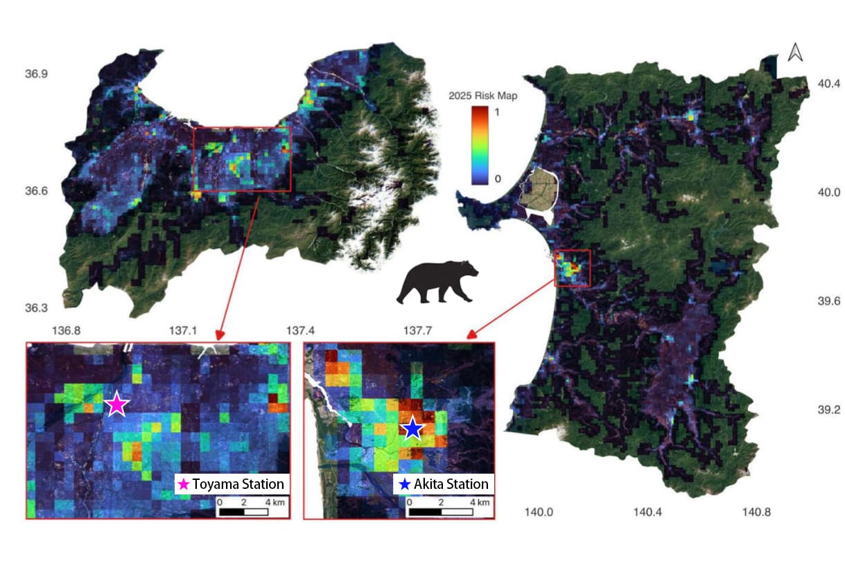
Human-bear interaction risk model for Akita and Toyama prefectures. Source: U-Tokyo IIS -
Fujitsu and the Tokai National Higher Education and Research System (THERS) announced the development of a new technology to predict solar radiation events. This system uses a "Wide Learning" AI technique to analyze past similar solar flares and predict radiation risks to satellites, power grids, and astronauts. While they can produce beautiful aurora displays on the Earth, solar flares and coronal mass ejections (CMEs) damage satellites, particularly in higher orbits and can affect both people and equipment in LEO as well as infrastructure on the Earth's surface. It's a particularly dangerous risk for lunar and Mars missions.
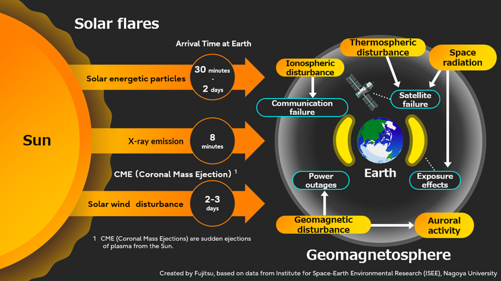
Impacts of solar activity and solar radiation events. Source: Fujitsu
🗺️ International Collaborations
- Synspective is establishing a subsidiary in Munich, Germany that will support SAR data sales and solutions in Europe, Africa, and Middle East [Synspective]. The outpost will be led by Iain MacInnes. This announcement follows on the heels of a strategic partnership with European industrial giant, Airbus Defence and Space [Synspective].
- Axelspace and JETHI Software Development, an Ethiopian technology firm, signed an MOU to support use of its satellite data in Ethiopia. The MoU creates a framework for collaboration on building applications for agricultural monitoring, resource management, disaster and climate risk management, and infrastructure planning.
- Why does this matter? Ethiopia's large agricultural sector and development challenges provide substantial opportunities for combining EO data with local data and position Axelspace to establish a market presence in East Africa while learning more about the emerging market requirements.
- On 3 February, the Mexican CubeSat Gxiba-1 was deployed from the International Space Station's Japanese Experiment Module (Kibo) through the KiboCUBE program (Space Daily), a partnership between JAXA and the United Nations Office for Outer Space Affairs (UNOOSA) designed for university-level research. Gxiba-1 was designed and built by a team from from the Popular Autonomous University (UPAEP) of the State of Puebla in Mexico after the university won the sixth round of the KiboCUBE program. UPAEP won the KiboCUBE slot in 2022 and delivered the completed satellite to JAXA Tsukuba Space Center for testing and integrate with the next HTV-X cargo launch in October. Now that it's deployed, UPAEP team is operating Gxiba-1. Its mission is optical observations of volcanic activity and volcanic ash dispersion.
- Why does this matter? KiboCUBE is a competitive program that offers cubesat deployments from the Kibo module to emerging and developing countries. While the program is designed to help universities and other research institutions to gain real world experience building and operating satellites, it's also a key source of Japanese soft power, cultivating relationships built around Japan's advanced technological capabilities. Once the satellite was built,
- ArkEdge Space (アークエッジ・スペース) has signed collaboration agreements [ArkEdge] [Japanese] with TrustPoint Inc. (USA), the Royal Institute of Navigation (RIN) (UK), and FrontierSI (Australia) to support development of its LEO-PNT satellite-based positioning and navigation system. ArkEdge is perhaps best known for its Earth observation satellites, but it is also developing maritime situational awareness for tracking movements of ships and a low Earth orbit (LEO) constellation to supplement the existing PNT systems (e.g. Galileo, GPS, Michibiki, etc.). The three organizations are quite different institutions. TrustPoint is building its own LEO positioning constellation. RIN is a research and professional society founded in 1947 as a forum for mariners, pilots, engineers and academics to share knowledge related to positioning and navigation. FrontierSI is an Australian nonprofit organization that carries out research and development related to geospatial applications, data analysis, and positioning. While different, each represents an anchor in one of three key Japanese defense and intelligence allies and can help ArkEdge develop a more useful LEO positioning and navigation system.
- Why does this matter? The current public PNT infrastructure – GPS, Galileo, Michibiki, and others – relies on satellites in orbits 20,000km and higher. While highly effective, the signals from these higher orbits are weak and subject to both jamming and spoofing, a scenario that is becoming increasingly common in Europe and the Asia-Pacific. In addition, almost every component of our society’s critical civilian and defense infrastructure – from transportation to emergency services and supply chains – relies heavily on these vulnerable positioning and navigation signals. As a consequence, there are multiple efforts afoot to develop mechanisms to either shore up existing satellite positioning signals or provide alternatives that will make the overall system more resilient. The Japanese Michibiki system is already a supplement to the U.S. GPS system and includes more resilient signals. Another potential solution is development of a satellite positioning system that operates in LEO (2,000 km or less) with stronger radio signals. This is one of ArkEdge’s goals, and JAXA has already funded ArkEdge to do an engineering feasibility study of a standalone LEO approach [GPS World]. These new partnerships represent a way to both learn about potential customer needs and assemble a coalition of organizations with a common objective. While it could be considered a competitor, TrustPoint could also potentially be shared infrastructure. Meanwhile RIN and FrontierSI are global thought leaders with deep experience on this topic. TrustPoint already has three test PNT satellites in LEO and is trying to build a constellation of 100. If TrustPoint and ArkEdge could share signal designs, they might both be able reach viable constellation size more rapidly together. Meanwhile, RIN and FrontierSI could help refine the system as well as cultivate support for the new infrastructure. Curiously, the U.S. Space Force recently announced it is ending its own effort [GPS World] to build a smaller, lower-cost navigation satellite constellation, known as Resilient GPS (R-GPS), without saying how it's going to deal with the spoofing and jamming problem.
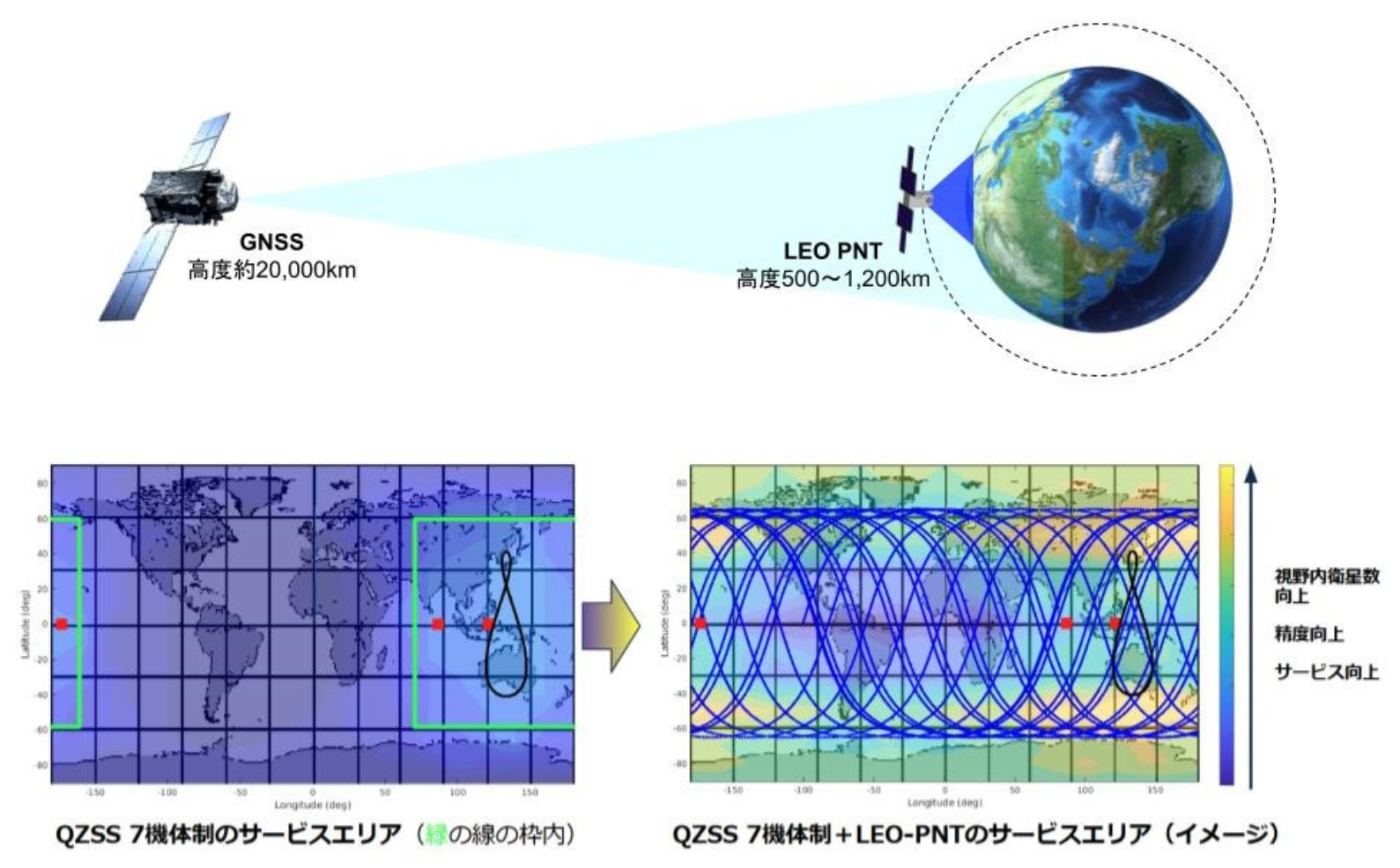
Diagram of the 7-satellite QZSS (Michibiki) system supplemented with LEO PNT. Source: ArkEdge Space
- Why does this matter? The current public PNT infrastructure – GPS, Galileo, Michibiki, and others – relies on satellites in orbits 20,000km and higher. While highly effective, the signals from these higher orbits are weak and subject to both jamming and spoofing, a scenario that is becoming increasingly common in Europe and the Asia-Pacific. In addition, almost every component of our society’s critical civilian and defense infrastructure – from transportation to emergency services and supply chains – relies heavily on these vulnerable positioning and navigation signals. As a consequence, there are multiple efforts afoot to develop mechanisms to either shore up existing satellite positioning signals or provide alternatives that will make the overall system more resilient. The Japanese Michibiki system is already a supplement to the U.S. GPS system and includes more resilient signals. Another potential solution is development of a satellite positioning system that operates in LEO (2,000 km or less) with stronger radio signals. This is one of ArkEdge’s goals, and JAXA has already funded ArkEdge to do an engineering feasibility study of a standalone LEO approach [GPS World]. These new partnerships represent a way to both learn about potential customer needs and assemble a coalition of organizations with a common objective. While it could be considered a competitor, TrustPoint could also potentially be shared infrastructure. Meanwhile RIN and FrontierSI are global thought leaders with deep experience on this topic. TrustPoint already has three test PNT satellites in LEO and is trying to build a constellation of 100. If TrustPoint and ArkEdge could share signal designs, they might both be able reach viable constellation size more rapidly together. Meanwhile, RIN and FrontierSI could help refine the system as well as cultivate support for the new infrastructure. Curiously, the U.S. Space Force recently announced it is ending its own effort [GPS World] to build a smaller, lower-cost navigation satellite constellation, known as Resilient GPS (R-GPS), without saying how it's going to deal with the spoofing and jamming problem.
📆 Asia-Pacific Conferences & Events
This newsletter is mostly focused on Japan, but I also like to highlight events across the Asia-Pacific region. Some upcoming conferences in 2026 include:
February 2026
- Urban Data Challenge 2025 Final - 21 Feb - University of Tokyo, Meguro,Tokyo
- 65th Virtual UNISEC-Global Meeting - 21 Feb - Remote
- Spacetide/Keio University Special Workshop “Introduction to the Space Business” (「宇宙ビジネス入門」特別公開講座) - 22 Feb, 8 Mar, 22 Mar - Keio University Mita Campus, Minato, Tokyo, Japan
- National Space Science Symposium - 23 - 27 Feb - Shillong, India
- Asia-Pacific Forum on Sustainable Development (UN ESCAP) - 24 - 27 Feb - Bangkok, Thailand
- ISAS Planetary Defense Symposium (17th Space Guard Research Meeting) プラネタリーディフェンス・シンポジウム(第17回 スペースガード研究会) - 26 - 27 Feb - JAXA Sagamihara Campus, Japan (Hybrid)
March 2026
- ISAS 40th Space Environment Utilization Symposium (第40回 宇宙環境利用シンポジウム) - 2 - 3 Mar - JAXA Sagamihara Campus, Japan
- 22nd Tanegashima Rocket Contest (第22回種子島ロケットコンテスト) - 3 - 5 Mar - Minamitane, Kagoshima, Japan
- JAXA Biz Dialog 2026 - 9 Mar - Nihonbashi, Tokyo, Japan
- 65th JSASS Aviation Engine and Space Propulsion Conference (第65回 航空原動機・宇宙推進講演会) - 9 - 11 Mar - Beppu, Oita, Japan
- ISAS Sounding Rocket Symposium (観測ロケットシンポジウム) - 12 - 13 Mar - JAXA Sagamihara Campus, Japan (Hybrid)
- Committee on Earth Observation Satellites (CEOS) Disaster and Information Services Working Group Meetings - 16 - 20 Mar - Dehradun, Uttarakhand,India
- Commercial Space Conference and Exhibition - 17 - 18 Mar - Shenzhen, China
- Tottori Rover Challenge 2026 (鳥取ローバーチャレンジ2026) - 19 - 21 Mar - Tottori, Japan
- Convergence India Expo - 23 - 25 Mar - New Delhi, India
- Space Technology Conference Central Eurasia (STC) - 30 Mar - 1 Apr, Tashkent Uzbekhistan
- GEO Connect Asia 2026 - 31 Mar - 1 Apr - Singapore
- Drones and Uncrewed Asia 2026 - 31 Mar - 1 Apr - Singapore
April 2026
- 57th Japan Society for Aeronautical and Space Sciences (JSASS) Annual Lectures (日本航空宇宙学会第57期 年会講演会) - 15 - 17 April - Osaka University Toyonaka Campus, Osaka, Japan
- International Conference on Spacecraft Mission Operations (SMOPS) - 8-10 Apr - Bengaluru, India
- International Conference on Advances in Aerospace and Energy Systems (IAES-2026) - 16-18 Apr - Mahendragiri, Tamil Nadu, India
- 11th China Space Day - 24 April - TBD, China - marks anniversary of China’s first satellite launch, Dongfanghong-1 in 1970
If you’ve made it this far, thank you for reading. Please be in touch via LinkedIn with any feedback, questions, comments, or requests for future topics. And if you have a friend or colleague that you think would enjoy JEO, please share it!
Until next time,
Robert
Again and again
I ask how high
the snow is.
-- Author: Masaoka Shiki (1867–1902) - translated by Janine Beichman
いくたびも
雪の深さを
尋ねけり
ikutabi mo
yuki no fukasa o
tazune keri