JEO 24 - News Roundup - 6 Nov 2026
Topping this news roundup, we have Astroscale’s proposal for “bodyguard” satellites plus the usual funding and contract announcements.
Welcome to Japan Earth Observer (JEO), a monthly newsletter about the space, Earth observation and geospatial industries in Japan.
The last two news roundups have been huge and probably annoying to read. In order to make the newsletter shorter. I’m going to shift to a weekly cadence that will also have the benefit of aligning with the YouTube channel. In this news roundup, we lead off with the Astroscale’s proposal for “bodyguard” satellites.
On to the news…
News & Announcements
🛰️ Technology and Infrastructure
Astroscale proposes "bodyguard" satellites
Astroscale has introduced the idea of creating "bodyguard" spacecraft that would launch with a primary payload and then provide protection services [Space.com] in proximity to a high value satellite. Alex Godfrey, Director of Defence and National Security at Astroscale, believes that they could have such protector spacecraft ready to launch within three years. The control and agility Astroscale has developed to approach, dock, refuel, or deorbit a spacecraft is similar to what would be required to safely operate in this type of protector role. Godfrey likened this to the more nimble and lower cost carrier strike group that protects a high value aircraft carrier.
Why does this matter? Over the past month, a Russian satellite, COSMOS-2612, has been shadowing and maneuvering close to an ICEYE SAR satellite. This has raised significant concern amongst NATO and other allied defense and intelligence agencies that this is practice for damaging or interfering with satellites that provide intelligence used by Ukraine in its war. This is not new behavior from Russia. Since 2014 its Luch-1 and Luch-2 satellites have been stalking European and American communications satellites in geostationary orbit. Germany's military space command chief recently admitted that they believe these Luch spacecraft have been intercepting European strategic communications for several years.
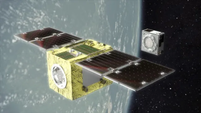
Illustration of Astroscale’s bodyguard satellite. Source: Astroscale.
Orbital Lasers signs R&D contract with JAXA
Orbital Lasers has signed an R&D contract with JAXA to develop a LiDAR altimeter and imager system payload [Orbital Lasers] that will be flown on a future HTV-X cargo vehicle. The new contract builds on previous design and prototyping work done under a 2024 contract and will include development of the instruments and on-orbit demonstration of the lasers, reception, and range measurement capabilities.
NASA currently operates a LiDAR instrument from orbit, but it can only measure along a line. Orbital Lasers has been developing a so-called "area-based" LiDAR technique that can measure a wide swath with a single laser pulse, generating a 3D point cloud of terrain and forests. The integrated imager system will generate high-resolution optical imagery to improve location accuracy.
The expectation is that a successful demonstration will lead to a future commercial LiDAR satellite constellation that will launch several commercial LiDAR satellites per year. Their goal is to achieve 3D point cloud accuracy and point density comparable to airborne laser survey instruments. I am frankly not convinced that a satellite from 300-500km can match airborne LiDAR, but large portions of the Earth are impractical or costly to survey using LiDAR. Airborne LiDAR is frequently used for infrastructure and land management, disaster response, forest management, and digital twins, and truly global access from will provide an important new data resource for managing our planet.
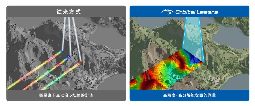
Diagram of Orbital Laser’s swath-based LiDAR. Source: Orbital Laser
IMV and Hulic announce new spacecraft test facility
Testing firm IMV and real estate developer Hulic have announced Japan's first commercial one-stop spacecraft test facility [SpaceMedia] to be built in Kawasaki, Kanagawa. IMV was established in 1957 and manufactures vibration and other testing equipment and other measurement instruments. It provides contract testing services for a range of industries, including automotive, railway, aerospace, and electronics. They already operate testing labs in seven locations across Japan.
Before satellites are launched, they typically undergo a series of environmental tests that include vibration, shock, thermal, vacuum, acoustic, and electromagnetic compatibility (EMC). Japan has testing environmental test facilities for small satellites weighing 50kg or less at the Fukui Prefectural Industrial Technology Center and Kyushu Institute of Technology. JAXA Tsukuba Space Center operates test facilities for larger satellites in the one ton or greater size. Testing facilities for other satellite sizes are scattered across multiple locations, necessitating additional cost, coordination, and transportation. The risk of damage also increases every time a satellite is transported to another location. The new facility will support the full range of environmental test services for 100-300kg class satellites with a specific focus on 200kg class satellites for which there is currently a lack of domestic test facilities. .
IMV and Hulic will not necessarily have to put up all of the funds for the new facility. IMV was selected in February 2026 as the lead of a team that won a JAXA Space Strategy Fund award [JEO] for "solving spacecraft environmental testing issues". Under that award, the team is supposed to cut test time and cost by 25-50%. The other partners on the Strategy Fund project are Osaka Metropolitan University and Kumamoto University (vibration/shock), Kyushu Institute of Technology (thermal vacuum) and TOA Corporation (acoustic).
Hulic and IMV plan to complete construction by March 2028. Kanagawa Prefecture already has a concentration of space-related companies, and the prefecture is actively promoting the concentration of space-related industries and collaboration among these companies
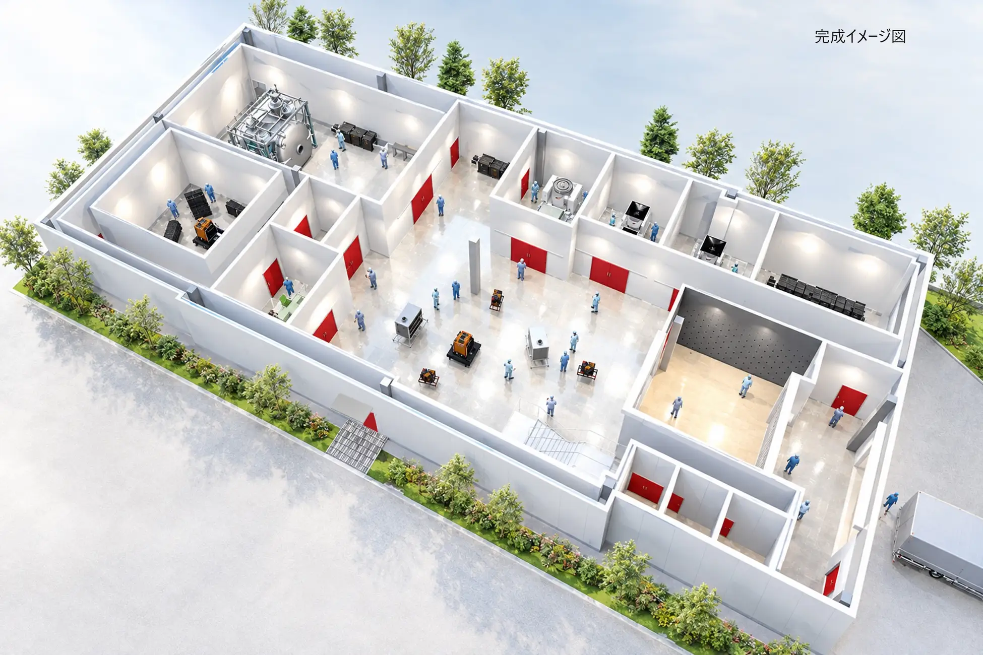
Artist rendering of the IMV and Hulic testing facility. Credit: IMV
MIERUNE releases KSJ Browser for QGIS Data Access
MIERUNE has released a new QGIS plugin for direct access to the National Land Numerical Information (国土数値情報) dataset from Japan's Ministry of Land, Infrastructure, Transport, and Tourism (MLIT). MLIT publishes national scale foundation data on administrative boundaries, land use, disaster prevention, facilities, and transportation. However, accessing and using this data usually requires searching the data website, downloading, and extracting a ZIP file, and then importing the files into a desktop GIS. This is quite a cumbersome process, particularly when dealing with multiple years, data layers, and data formats.
MIERUNE has several years of experience teaching people how to use public datasets in QGIS. The new KSJ Browser (KSJ refers to the Japanese name for the dataset: Kokudo Suuchi Jouhou) aims to simplify the "search, download, unpack, and load" process by providing a simple user interface inside the QGIS software. The plugin not only simplifies the process, manages historical data and legacy data formats, integrates metadata, and provides a toolbox that can be automated using Python.
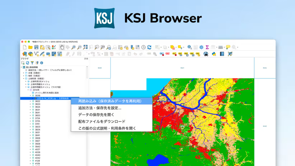
MIERUNE KSJ Brosser. Credit; MIERUNE
💱 Contracts
- Astroscale's UK subsidiary won a contract from the UK Ministry of Defence [Astroscale] for £15 million (~US $20 million) for Project LEDA, working with BAE Systems and Open Cosmos. The project will develop mechanisms to protect critical orbital infrastructure, including a recent idea As noted above, Astroscale also introduced a "bodyguard" satellites concept this week (see above), and this contract also aligns with the increased emphasis on space in the new UK Defence Investment Plan, which allocates £3.2 billion to space through 2030.
- Axelspace has signed a MoU with Manastu Space Technologies, a propulsion thrusters firm based in Mumbai, India. Manastu's thrusters use "MS-289", a proprietary hydrogen peroxide/alcohol-based propellant that is safer and more environmentally clean that hydrazine and many other propellent fuels. Under the new agreement, the two companies will assess the technical requirements for integrating and testing Manastu's technology into future Axelspace spacecraft [Axelspace]. AxelLiner Lab (AL Lab) is a service Axelspace offers for on-orbit demonstrations of satellite components in order to obtain flight heritage. Axelspace already has an AL Lab customer, ASPINA, flying a reaction wheel component on a GRUS-3 satellite launched in July. Axelspace also has an AL Lab contract with JAXA. Manastu is Axelspace's first overseas AL Lab customer
- ElevationSpace has signed an MoU with the German Aerospace Center (DLR), the German national space agency, to cooperate on space transport, use of microgravity environments for manufacturing, and testing of materials [SpaceMedia] returned from orbit. DLR operates an array of ground test facilities and analysis capabilities. It also has significant experience launching and recovering sounding rockets. ElevationSpace has been developing the ELS-R small satellite for conducting microgravity experiments and returning the results to Earth.
- What does this mean? Bringing materials back to Earth from orbit requires complex technologies to both withstand the extremely harsh aerodynamic heating that occurs during atmospheric re-entry and to guide and control the spacecraft. Development and testing of these technologies generally uses ground testing facilities such as wind tunnels and numerical simulation, but it's difficult to completely simulate the actual re-entry environment on the ground. DLR's flight heritage using sounding rockets will provide crucial data. The joint research should enable the two organizations to improve their knowledge of aerodynamics, thermal protection, and flight control for re-entry vehicles. DLR perceives a need for a new re-entry vehicle to meet European demand and work also anticipates the de-orbit of the ISS in 2030.
- Japan Airlines (JAL) and SKY Perfect JSAT have signed a business alliance agreement to combine SKY Perfect JSAT's satellite data and analytics with JAL's aviation safety expertise and its networks in local communities [SKY Perfect JSAT]. An initial project will focus on developing a solution for visualizing risks of wildlife encounters (bear encounters have been a major issue in recent years). Later projects will take up disaster prevention and mitigation, forest management, environmental monitoring, and infrastructure management. In addition to building new software and data solutions, the agreement will include running demonstrations for local governments and private firms and developing business models.
- Both iQPS and Synspective have both signed joint research agreements with the National Institute for Land and Infrastructure Management (NILIM, 国総研 - 国土交通省国土技術政策総合研究所), part of Japan's Ministry of Land, Infrastructure, Transport and Tourism (MLIT). The two agreements both aim to develop new techniques for rapidly detecting fire damage from SAR satellite data. NILIM has significant fire science expertise as well as field survey and damage analysis data from past wide-area fires. The work will correlate past fire damage with SAR observations from iQPS's and Synspective's constellations. Faster damage assessments will improve initial response and recovery from wildfires.
💴 Equity Funding
- Preferred Networks (PFN) signed a business and capital alliance with Zenrin and its subsidiary Zenrin DataCom. The goal is to combine Zenrin's high-precision geospatial data, which carries a time dimension and a "change history", with PFN's AI. Zenrin and Zenrin DataCom will subscribe to a third-party share allotment by PFN - that’s the capital investment part. For this partnership, Zenrin is defining use cases and commercialization opportunities, Zenrin DataCom is planning and developing services; and PFN is developing AI models that can reason over geospatial information using a mix of generative AI, physical AI, and image/3D spatial recognition. The partners will work together on four areas:
- Geospatial AI models
- Industry- and task-specific AI services
- Restructuring geospatial data to be "AI-Ready"
- A shared technology platform
- Why does this matter? This is a very interesting deal between a leading physical AI firm and a leading geospatial data firm to create geospatial foundation models and 3D/spatiotemporal world-models. This kind of combination is fairly unusual and worth paying attention.
- Toyota Ventures co-led a US$20M investment in U.S. startup [SpaceConnect] Rendezvous Robotics. Toyota was joined by MaC Venture Capital with additional participation from the University of Michigan endowment, Astera, and Industrious Ventures. The technology being developed by Rendezvous Robotics builds on MIT's TESSERAE self-assembly research [YouTube]. The team is developing hexagonal modules that use electromagnets and mechanical latches to assemble and reconfigure modules into larger spacecraft in orbit. The new funds will go to spacecraft development, flight demonstrations and hiring. They plan a demonstration on the ISS in December 2026 using 32 panels and then a mission in 2028 that will assemble, separate and reconfigure 7 modules.
- Why does this matter? Rocket payload cylinders limit the size and shape of orbital spacecraft. If smaller modules can self-assemble into larger structures, they will be able to gain the benefits of larger scale, be able to add or replace functionality, and repair busted components.
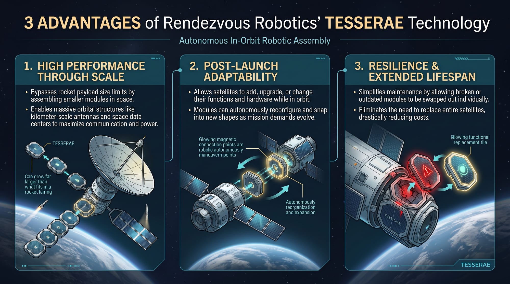
Diagram outlining how TESSERAE can support more scalable, flexible satellites. Source: JEO, generated from Gemini
🔭 Science
- The Kyushu Institute of Technology and JAXA have developed the world's first AI-based technique for detecting surface charge (表面帯電) on satellites [Sorae]. Satellites cannot be grounded (because, well, they aren't on the ground) so they tend to build static electricity on their surfaces, and if the charge becomes too great, it will discharge, which can damage solar cells, surface materials, and electronics. The new technique uses a convolutional neural network (CNN) to detect discharge events. The machine learning model was trained on 3,000 observation events from a U.S. military meteorology satellite, DMSP F16, gathered from 2005 to 2023.
- The research shows that charges build up from interaction with high-energy electrons associated with aurora events and diminish through interaction with ionospheric plasma. The balance between these two flows determines the amount of charge that builds up. The aim of the research is to be able to predict when and where satellites are prone to this surface charge buildup in order to operate satellites more safely.
- The research was published in the Oct 27 issue of the AGU's Space Weather journal.
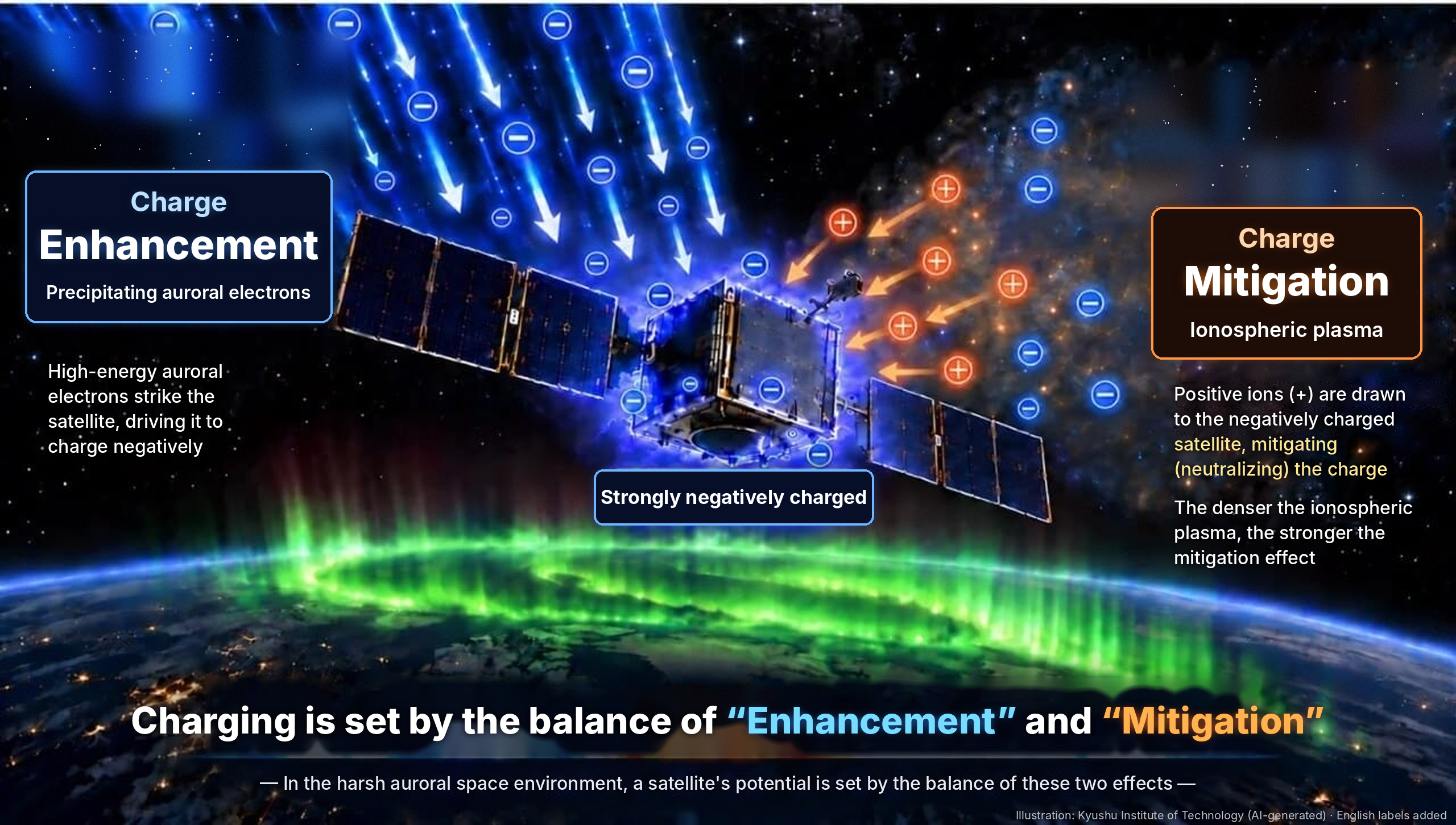
Diagram of surface charges on satellites. Source: Kyushu Institute of Technology w/ JEO translations
🗺️ Elsewhere in the Asia-Pacific Region
- Indian Space Research Organisation (ISRO) has successfully placed the NVS-03 navigation satellite into its designated geosynchronous orbit [ISRO] to become part of the NavIC navigation constellation. The satellite was launched on 30 October from the Satish Dhawan Space Centre on a GSLV-F18 rocket. After four orbit-raising maneuvers it has reached its target geosynchronous orbit at an inclination of 29.98°. This is a big deal. ISRO’s NVS navigation system is similar to Japan’s: it is focused on the region over India and needs a minimum of four satellites to function. The regional system has been crippled for years after a series of atomic clock failures and a propulsion failure in 2025 that prevented NVS-02 from reaching its target orbit. India plans two more NVS satellite launches in 2027 to improve the system’s resilience and longevity.
📆 Asia-Pacific Conferences & Events
This newsletter is mostly focused on Japan, but I also like to highlight events across the Asia-Pacific region. Some upcoming conferences include:
November 2026
- TASTI 2026 (TASA Taiwan) - 8 - 11 Nov - Tainan, Taiwan
- 2nd Nano-satellite IoT Constellation Program Workshop - 8 Nov - Tainan, Taiwan
- 3rd Deep Space Workshop - 8 Nov - Tainan, Taiwan
- 9th Asia-Oceania Space Weather Alliance Workshop - 8 - 11 Nov - Tainan, Taiwan
- 10th Mission Idea Contest Preliminary Workshop (PreMIC 10) - 9 Nov, Tainan, Taiwan
- 15th Nano-Satellite Symposium - 9 - 11 Nov - Tainan, Taiwan
- SPIE Asia-Pacific Remote Sensing 2026 - 9 - 12 Nov - Yokohama, Japan
- Advancing Earth Observation Forum 2026 - 9 - 12 Nov - Hobart, Tasmania, Australia
- Australian Space Domain Awareness and Space Traffic Management Conference 2026 - 10 - 12 Nov - Canberra, Australia
- 7th China International SAR Symposium (CISS 2026) - 10 - 12 Nov - Nanjing, China
- 70th Space Science & Technology Conference (第70回 宇宙科学技術連合講演会) - 10 - 13 Nov - Utsunomiya, Japan
- Korea Society for Aeronautical and Space Science (KSAS) 2026 Fall Conference - 10 - 13 Nov - Seoul, South Korea
- China International Aviation & Aerospace Exhibition (Airshow China) - 10 - 15 Nov - Zhuhai, China
- International Symposium on the Peaceful Use of Space Technology (ISPACE) - Health 2026 (IPSPACE 2026) - 16 - 19 Nov - Haikou, China
- International Workshop on ATM/CNS (IWAC 2026) - 17 - 19 Nov - Tokyo, Japan
- JAXA Space Debris Workshop 2026 (第12回スペースデブリワークショップ) - 18 - 20 Nov - Tokyo, Japan
- Indo Aerospace Expo and Forum - 18 - 21 Nov - Jakarta, Indonesia
- 8th Satellite Science Workshop and Taiwan Space Union Annual Meeting - 20 - 21 Nov - Taipei Taiwan
- International Lunar Sample Research Symposium 2026 - 20 - 23 Nov - Hong Kong, China
- India International Space Conclave 2026 - 23 - 24 Nov - New Delhi, India
- Locate26 - 24 - 26 Nov - Melbourne, Australia
- 10th Digital Earth Summit - 24 - 26 Nov - Melbourne, Australia
- 13th Hayabusa Symposium / Space Materials Science Symposium (第13回 宇宙物質科学シンポジウム) - 24 - 27 Nov - Sagamihara, Japan
- 35th Space Engineering Conference (SEC'26) - 27 - 28 Nov - Osaka, Japan
- FOSS4G Hokkaido 2026 - 28-29 Nov - Kita Hiroshima, Hokkaido, Japan
- CEOS WGCV SAR Calibration & Validation Workshop 2026 - 30 Nov - 4 Dec - Perth, Australia
- Asian Microgravity Symposium 2026 (AMS2026) - 30 Nov - 4 Dec - Hyogo, Japan
- ISRO-ESA GEOGLAM Joint Workshop on Agricultural Monitoring 2026 - 30 Nov-4 Dec - Ahmedabad, India
- Nihombashi Space Week 2026 - 30 Nov - 12 Dec - Tokyo, Japan
- Tanegashima Space Art Festival - 21-22 Nov and 5-6 Dec - Tanegashima, Japan
December 2026
- IEEE India Geoscience and Remote Sensing Symposium (InGARSS 2026) - 1 - 4 Dec - Hyderabad, India
- 14th International Conference on Communications, Networks, and Satellite (IEEE-COMNETSAT 2026) - 3 - 5 Dec - Manado, Indonesia
- Global New Space Forum 2026 - 4 - 5 Dec - Seoul, South Korea
- 16th Asia-Oceania Meteorological Satellite Users Conference - 6 - 11 Dec - Melbourne, Australia
- Symposium on Space Flight Dynamics FY2026 (宇宙航行の力学シンポジウム) - 7 - 8 Dec - Sagamihara, Japan
- 8th Singapore Space Symposium - 7 - 9 Dec - Singapore
- 18th AOGEO Symposium - 15 - 17 Dec - Tsukuba International Congress Center, Ibaraki, Japan
- 41st Space Structures and Materials Symposium (ISAS/JAXA) - 17 Dec - Sagamihara, Japan
- National Conference on Legal Dimensions of Space Governance, Sustainability and International Cooperation - 18 - 19 Dec - Thiruvananthapuram, Kerala, India
- AEC Forum (Geospatial + BIM + Digital Twins) 2026 - 21 - 22 Dec - Bharat Mandapam, New Delhi, India
If you’ve made it this far, thank you for reading. Please be in touch via LinkedIn with any feedback, questions, comments, or requests for future topics. And if you have a friend or colleague that you think would enjoy JEO, please share it!
Until next time,
Robert
Autumn deepens
the man next door, what
does he do for a living?
–- Matsuo Bashō (松尾 芭蕉, 1644–1694) - translated by Ueda Makoto
秋深き
隣は何を
する人ぞ
Aki fukaki
tonari wa nani o
suru hito zo